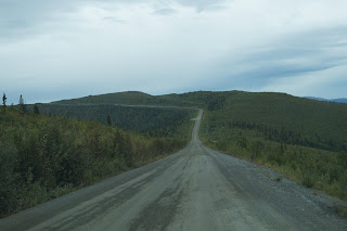
Do you know what / where the Top of the World Highway is? No?
Don’t blame you, I didn’t know about it either before starting our trip but
am definitely glad that it made it onto our “To do” list. This seasonal highway
goes from Dawson City to Chicken and then connects to the Alaska Highway near
Tok, AK. Most highways follow the river valleys, but not this one. It goes along the mountain tops. Hence the
name.
What it really should be called is the OMG Holy #$%&
Highway! Since it travels the tops of the mountains, all the views are down. And
down and down. The tops of the mountains are relatively flat, so you get these
amazing vistas. But sometimes, when you’re cutting across the edge of the
mountain, with no guard rails, it’s a bit scary. We took plenty of pictures,
but they really can’t do it justice.
We pulled into Chicken, a small mining town along the
highway (called the Taylor Highway in Alaska) and found a spot for lunch. Chicken
is an interesting place, and not one many people will see in their lifetimes (and
I didn’t get ANY pictures to prove we were there. Bah!). Its population is 15 in the winter and 30-50
in the summer. There are only 3 businesses in town, but they have gas/diesel,
cafes, campgrounds, and even wifi. This is a true fringe town, though, and solar
panels & generators are strongly in evidence. There is no outside sourced electricity,
no running water, no flush toilets. We ate at the Downtown Chicken café (very
good food), and I got a sticker to put on the trailer at the gift shop. I
wonder how a town of 15-50 manages to keep up with the tourist/ hunter traffic
and demand for services. (A Holland
America tour bus, on its way over the Top stopped into the café just as we
finished up lunch.)
Perhaps the gold that is still being mined in the area helps balance out the lopsided tourist season.  |
| Border Crossing |
 |
| Alaska side construction |


